

Frequently Asked Questions:
We aim to create a resource of frequently asked questions in order to assist all on line customers outside of office hours.
If the answers you require aren’t listed here please contact us or enter your question on the form below. We’ll answer you promptly and add your question/answer to the list.
Thank you for collaborating on this important topic.
General Questions
What Cattle Tag Applicator do I have?
To find out what cattle tag applicator you have please CLICK HERE
What is RFID or EID?
RFID stands for Radio Frequency Identification, and it is also referred to as Electronic Identification (EID).
An RFID ear tag carries a unique electronic identification number and allows animals to be electronically recognised and data stored automatically about each animal.
On farm, an RFID system consists of:
- Tags: house the transponder that hold and sends the identification information
- Readers: energises the transponder of the tag and receives identification information
- Data Collectors: stores the identification information
- Data Processors: uses the information and provides outputs of data.
RFID tags are available in two technologies, Half Duplex (HDX) and Full Duplex (FXD)
What's the difference between HDX and FDX tags?
HDX (Half Duplex)
HDX talks to the reader like a 2 way radio, the reader sends out a signal then the tag replies
Several dairy sheds systems are HDX only which makes this type of technology the most popular choice within dairy farmers.
Some older cattle crushes with a lot of metal noise are better suited to HDX
FDX (Full Duplex)
FDX is like a phone conversation; as soon as the tag receives the reader signal both tag and reader talk simultaneously.
FDX is ideally suited to most sheep and beef environments
FDX is also suited to most deer shed environments
When should I use FDX Tags?
FDX RFID tags are suited for use with RFID wands.
FDX performance varies with different types of panel readers; therefore it is important to get expert advice as to which reader to install.
- Non-noisy environments such as wooden deer yards
- Narrow races with a panel reader like a sheep race
- Sheep weigh crates
When should I use HDX Tags?
HDX RFID tags are suited for use with RFID wands
- HDX performs with most types of panel readers
- In sheep weigh crates
- In automated dairy or beef systems
- When using a panel reader for cattle, sheep & deer
- In a noisy and high metal environment like dairy sheds
What are Year Colours & Year Letters
For details of recommended Year Colours and Year Letters please CLICK HERE
Est. Leadtimes from order to despatch?
For the latest estimated lead times for tag manufacturers please CLICK HERE
Reader Manuals & Apps
For more detailed information with regards to RFID (EID) Readers (Scanners) and Applications, visit our dedicated downloads section. please CLICK HERE
Latest News
To see our latest news items please CLICK HERE
LoRaWAN GPS Cattle Tags & Networks
What is the internet of things for agriculture?
IOT refers to sensors/monitoring devices (things) which are connected to the internet via a cloud-based network server.
The server allows the data/information from the “things” to be used and interpreted by applications and third-party software.
Importantly, information is sent in small, low power packets, allowing devices to be powered by small batteries and solar panels.
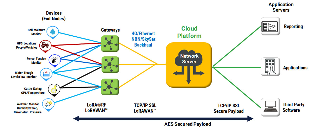
How do LoRaWAN connected GPS devices work?

You will set up your own LoRaWAN network using a gateway (box) with an antenna connected. Each gateway is powered by mains or a battery re-charged using a solar panel. Each gateway is connected to the internet (cloud) by either a landline, 4G or Satellite depending upon the subscription and coverage availability.
Within the network range, your eartags (and other IoT devices) registered to you will be monitored. Devices registered to your neighbour which are picked up by your network will not be visible to you. Likewise your animals showing in your neighbours network will not be visible to them.
Power consumption of the tag/device is proportional to the time/frequency devices spend listening.
What is LoRaWAN?
![]()
Long Range Wide Area Network ( LoRaWAN ) is a low-power wireless network protocol. The LoRaWAN specification is set by the LoRa Alliance, is freely available and utilizes Semtech Corporation’s proprietary Chirp Spread Spectrum Modulation technique “LoRa”.
It is asymmetrically aligned with the energy efficiency of the IoT devices and achieves high ranges (> 10 km ) for the uplink communication, ie the transmission from the IoT device to the network. The data transfer rate ranges between 292 bps and 50 kilobits per second. Different operating levels down to a quasi-continuous downlink Communication is possible, the latter at the expense of energy efficiency.
The network architecture is star-shaped. Terminals communicate with gateways that send the data packets to a network server. The network server has interfaces to connect to IoT platforms and applications.
LoRaWAN uses regionally different frequency ranges in the ISM band and SRD band. Among other things, in Europe these are the frequency band from 433.05 to 434.79 MHz (ISM Band Region 1) and the frequency band from 863 to 870 MHz ( SRD Band Europe). In North America, on the other hand, the frequency band from 902 to 928 MHz (ISM band region 2) has been released for data transmission.
The ranges extend from 2 km (urban area) over 15 km (suburbs) to 40 km (rural areas). Another great advantage is the penetration of buildings, as it can also be supplied to a certain extent underground premises.
The power consumption of terminals is around 10 mA and 100 nA in sleep mode. This allows a battery life of 2 to 15 years, depending on the application. The communication between the terminals and the gateways takes place on different frequency channels with different data rates. These are between 0.3 kbit / s and 50 kbit / s.
In order to achieve high efficiency in data transfer and energy consumption, LoRaWAN uses frequency spread. Interference can be avoided as much as possible. The data transfer rates to the terminals are adapted by the network server to the respective situation (ADR = adaptive data rate).
The communication in the LoRaWAN is encrypted in duplicate with 128 bit AES, on the one hand to the network server and on the other to the application server.
How is the coverage of LoRaWAN calculated?


There are a number of factors effecting coverage such as size/spec of the gateway, length of antenna, elevation (height at which it’s installed) and topography (presence of hills). These factors control RSSI (Signal Strength) and SNR (Signal to Noise Ratio).
Assuming a standard installation located at single story roof height, typical coverage would be 10km. A 10km signal radius from each gateway means a coverage area of approximately 310 sq km or 77,000 acres. Three gateways installed would therefore provide both trilateration location using less power than GPS and cover area in excess of 200,000 acres.
Considering the factors that effect range of reading (including power of the tag or device), the longer the distance (link), the higher the antenna needs to be due to the earths curvature. See image explaining the Fresnel Zone.
Tree tops can deflect and absorb some of the signal. The theory is that the height of the tallest object in the path of the signal should be added to the Fresnel Zone and earth curvature clearance heights. It is important to check the height of the trees, hills, buildings or any object on the link path and add this to the measurement for the total of the tower height. There are three main categories of LOS, the first being full LOS where no obstacles reside between the two antennas. Non Line of Sight (NLOS) where full obstructions exist between the two antennas. See image explaining Line of sight.
For optimal network coverage two or more antenna/gateways are recommended and coverage blackspots can be filled using smaller specific gateway/antenna set-ups.
How are GPS co-ordinates obtained?
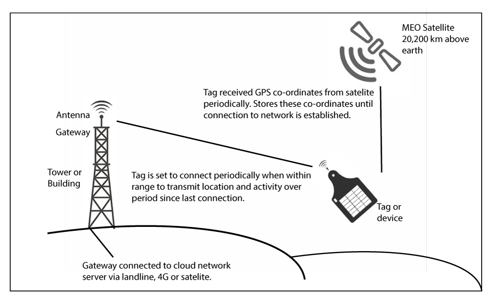
GPS satellites fly in medium Earth orbit (MEO) at an altitude of approximately 20,200 km (12,550 miles). Each satellite circles the Earth twice a day.
Tags connect to the GPS satellite obtaining and storing their location co-ordinates at a particular time. Similarly other information such as temperature can be captured.
Periodically connecting to the LoRaWAN network, the information stored (co-ordinates etc) is transmitted to the gateway and onward to the cloud network server for interpretation by visualisation dashboards and apps.
Official Resources
OSPRI & NAIT Contacts?
Still Have Any Questions?
We’re committed to providing the best Customer Service possible! You can contact any one of our dedicated team Monday to Friday from 9am to 6pm AEST.
Call 0800 224 010 You can also Email Us.